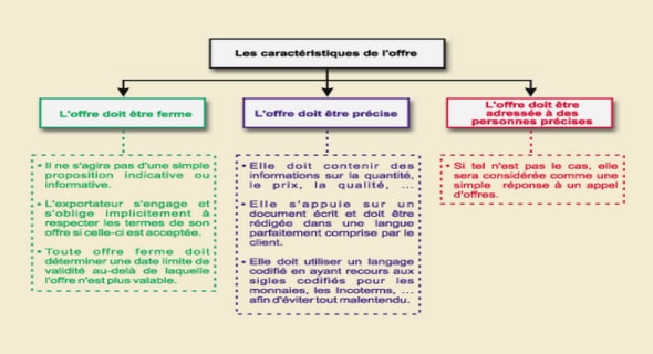
Cours results and primary interpretations color composites, tutoriel & guide de travaux pratiques en pdf.
Band ratioing and zonal statistics
As discussed in 3.6.2, the band ratioing transformations we conducted had as aim to reveal spectral reflectance of various features that we intended to observe. Figure 21 presents an overview of band ratios new rasters received for Sentinel-2A. In order to evaluate ratios outcomes, we implemented zonal statistics calculations around our two sampling points in the lake GE3 and SHL2 (Figure 12 in 3.3). Zonal statistics results were plotted in column charts for each band ratio and each of the two sampling sites. Figure 22 and 23 demonstrates the results for Sentinel-2A image, for the two different sampling sites. A full overview of the resulting tables from ArcGIS is given in Appendix A11. An evaluation of zonal statistics results is attempted using the in situ retrieved results, as discussed in 3.3. The in situ results can be seen in Table 5 and 6 hereafter. For the latter, we took into account average values for depths up to 10 m, which is presented in the tables in red.
From the charts in Figures 22 and 23 we can see that the majority of band ratios give lower average values around the SHL2 sampling point, except for the S2A 2/8 and the S2A 3/4 ratio. The GE3 sampling point is in a less deep part of the lake, richer is dissolved substances and algae, which we would expect to increase total reflectance of the water and result to overall higher ratios. Nonetheless this depends on the ratio, the S2A 2/8 ratio is expected to have higher values in a part of clearer, deeper, open water area. Additionally, as mentioned before, the fact that we did not implement any atmospheric correction to our images probably results to misleading measured reflectance, especially in the band of red, for the S2A 3/4 ratio.
The band ratio S2A 2/8 (blue/NIR) gives, relatively to other bands, higher values for both sites, since water absorbs in the NIR and its reflectance is higher in the blue of the visible range. However, the ratio gives higher values in the SHL2 site which is a more open and clear water part of the lake, than in the GE3 less profound and close to the shore. The lower values of the same ratio in the GE3 site is expected, as it is richer in Chl-a (as presented in Tables 5 and 6) and part of the blue light is absorbed by algae.
The ratio S2A 4/8 (red/NIR) is expected to show a satisfying correlation with Chl-a content and we would expect to have lower values for the sampling point richer in Chl-a. Indeed, we see that the ratio showed a lower value at the GE3 sampling point, correlating with our in situ dataset.
From the rest of the bands, the ratio S2A 3/4 (green/red) would be expected to also correlate and reflect Chl-a content in the two sites , with higher values in parts of the lake with higher Chl-a content, as it absorbs in the red and has higher reflectance in the green. However, the ratio gives higher values in the SHL2 site (2.14), where we found lowest Chl-a content from the in situ measurements. In GE3 site the ratio shows lower average pixel values (1.42). We see then that due to the overlapping absorbance in the blue and green, this ratio does not conclude to a good Chl-a representative. Nonetheless, it is indispensable to apply atmospheric correction for retrieving accurate vegetation results. Additionally, it is important to notice that Sentinel-2A band configuration, offers 4 distinctive narrow bands for vegetation evaluation, which we did not use in this analysis. We only used the wider bands, closer to the Landsat band configuration.
Figure 24 presents band ratios’ rasters, resulting from the Landsat 7 ETM scene. Here, we can see the lower level of visual quality results compared to Sentinel-2A band ratioing. There is always the stripping noise which is actually no data values and is important to be noticed at this point. Figures 25 and 26 hereafter, present the column charts of zonal statistics outcomes derived from the Landsat 7 ETM scene. Also here, the ratio ETM 1/4 (blue/NIR), shows higher values (1.69) in the SHL2 site (less turbid clearer water), and lower values (1.47), in the GE3 sampling point (more turbid higher Chl-a content), as expected. The ratio ETM3/4 (red/NIR) shows also correlation with the in situ data Chl-a content, giving a lower value in the GE3 sampling point. The ratio green/red ETM 2/3 is an interesting observation here, giving higher values for the GE3 point (4.04) and lower values at the SHL2 point (1.37), which is different to what we acquired in the Sentinel-2A scene. We see thus an inconsistency in the green, blue bands of the two satellites.
Indexes
Indexes are very useful tools in remote sensing for retrieving optical active components concentrations in water bodies. The indexes presented in 3.6.3, were applied separately in our Sentinel-2A and Landsat 7 scenes.
With respects to Sentinel-2A image, Figure 27 shows the result of classic satellite remote sensing NDVISRS index.
The index gave values from -0.50 to +0.88. Lower values are presented in blue, close to zero values in yellow and higher positive values in red. This index, as discussed, incorporates bands 4 (red) and 8 (NIR) and is mostly used in retrieving soil vegetation. Strong vegetation absorbs most of visible wavelengths and reflects most of the NIR. Positive values close to 1 are considered as vegetated areas, values close to -1 represent water or humid areas and values close to 0 are generated from features of high brightness, bare soil or clouds.
We can see that the ratio shows indeed higher values in the parts of intensive vegetation. For the areas around the lake where vegetation type changed, with less robust vegetation, crops and constructed areas the index is close to 0 painting these areas yellow. The areas of strong vegetation the NDVI takes high positive values painting them red in the figure. With respects to the water body area, which is our main interest, we wouldn’t expect any color variations from this index. The lake appears blue, with index values very close to -1 as water absorbs most of the NIR radiation and has low reflectance in the red overall.