- Sunday
- May 19th, 2024
- Ajouter un cours
Analyse InSAR des déformations de volcans actifs Atmospheric contribution Origin of atmospheric phase delay In repeat-pass InSAR measurement, the two interferometric SAR images are not simultaneously acquired. The propagation path of radar signal for each acquisition can be affected differently...
Structure du paysage et fonctionnement hydrologique Study area General description The study area is the cultivated portion of the Hérault French département of the LanguedocRoussillon région, in the south of France. We did not consider the northern mountainous region, where...
Analyse InSAR des déformations de volcans actifs Development of Interferometric Synthetic Aperture Radar Interferometric Synthetic Aperture Radar (InSAR), also referred to as SAR Interferometry, is a recently developed technique of geodesy, based on the phase difference between two SAR images....
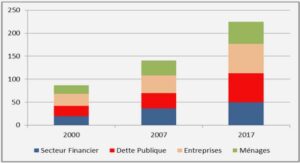
Modélisation numérique de la marée interne Impact sur l’environnement océanique Par le biais de tous ces processus, les ondes internes jouent un rôle primordial pour le transport de chaleur, de sel, d'éléments nutritifs, de polluants et de sédiments. Les forts...
Nouveau modèle tectono-climatique des Andes Centrales du Nord (5-9°S) La subduction La subduction de la Plaque Nazca sous la Plaque Sud-Américaine est le processus géodynamique à l’origine de la structuration des Andes depuis au moins le Jurassique moyen (e.g. Coira...

Morphologie du paysage agricole et liens avec la variabilité spatiale de l’épaisseur des sols Objectifs et principaux résultats Ce chapitre vise à déterminer les relations existant entre certains éléments linéaires de la morphologie du site d’étude et la variabilité spatiale...

Diagnostic of the Ibity New Protected Area Protected areas in Madagascar The IUCN defines protected areas as “a clearly defined geographical space, recognized, dedicated and managed, through legal or other effective means, to achieve the long-term conservation of nature with...
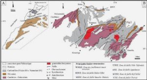
Lesser Antilles Island arc Martinique is located in the central part of the Lesser Antilles Island arc, which results from the westward subduction of the Atlantic plate under the Caribbean plate (Fig. 1a). Whereas in the southern part of the...
Le chronotope du seuil Le chronotope de la route apparaît ainsi comme une condition nécessaire mais non suffisante du road novel et du road movie. En effet, sa présence structurante au sein d’une œuvre ne garantit pas l’appartenance de cette...
A myriad of geomorphic expressions consisting of fascinating physical landscapes and intricately sculpted landforms envelop the upper lithosphere of our planet. The scientific analysis of Earths landscapes and the investigation of processes that mold landforms are the fundamental facets of...