Seasonal variations in processes driving manganese
Description and soil types in study area
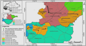
The city of Cotonou is bordered by the Lake Nokoué in the North, and the Atlantic Ocean to the South (Fig. 1). Cotonou is located in the hot and humid sub-equatorial climate zone, characterized by two annual rainy seasons (March to July and September to October) and two dry seasons (November to March and August). As shown in Figure 1A, the different types of soil in Cotonou are: i) tropical ferruginous soils leached without concretions on Quaternary sand (orange color), ii) hydromorphic soils leached on Quaternary sand (blue color), iii) hydromorphic soils with little humus on clay alluvial material (green color) and iv) soils with little hydromorphic development on coastal marine sands. The hydromorphic soils common in the coastal areas of southern Benin are characterized by a longterm oxygen deficit that promotes redox processes. These soils are classified as highly to moderately acidic pH soils (Azontonde 1991; Igue et al. 2013)
Geology and granulometry
Cotonou is located in the coastal sedimentary basin comprised of Quaternary (Holocene) sediments, which include facies of the littoral plain (sands) and alluvial deposits, underlain by sediments from the MioPliocene (Continental Terminal), Paleocene and Upper Cretaceous (Maliki 1993). The Cotonou aquifer is based on the Quaternary aquifer identified at the level of the coastal sedimentary basin. The particle size fractions found in « Holocene sediments » are composed of fine to medium sand (85%), silt (5.5%) and clay (9%). The content of fine particles (silts + clays) is less than 17% and those of sands can reach 95% (Oyédé 1991). They are therefore homogeneous sediments with a low clay content. Most of the silicates present in the barrier beaches are, in addition to silica itself, clays. These are kaolinite and smectites (including montmorillonite) for yellow sands and smectites only for white and brown sands. Traces of limestone from recent marine or coastal (lagoon) deposits frequently strewn with shell debris are also present (Boukari 1998). The granulometric analysis carried out by Oyédé (1991) and Maliki (1993) on the PU2 piezometer (not far from the beach and about 200 m from the Atlantic Ocean) made it possible to obtain the lithological section shown in the Figure 2
Groundwater contamination by iron and manganese
The iron may have an oxidation state of +2 or +3. The stability of the ions Fe2+, Fe3+, Fe(OH)2+, and Fe(OH)+ with respect to Fe(OH)3 and Fe(OH)2 precipitate or colloidal depends on pH, Eh, and the composition of the solution. Manganese presents three possible oxidation states in such environments rather than two (+2, +3, and +4) and can form a wide variety of mixed-valence oxides (Hem 1985). The chemistry of manganese is somewhat like that of iron. In general, manganese occurs as Mn2+, which easily oxidizes to MnO2 and may form stable organic complexes, as iron does. The main sources of Fe2+ include the dissolution of iron (II) bearing minerals and the reduction of iron oxyhydroxides (Fe-OOH) present in the sediments and clay minerals such as smectites (Appelo et al. 1994). Very few studies have actually focused on metallic trace elements in groundwater and surface water. This is due to the absence or the limited data base on water resources in the coastal zone of southern Benin compared to other African countries. Moussa Boukari (1998) had shown that total iron contents are generally between 0.1 and 0.2 mg/L, which is below the WHO (World Health Organization) guideline of 0.3 mg/L. As far as zinc is concerned, the levels are between 0.5 and 1 mg/L and are also not harmful to water quality. Nevertheless, sectors with high zinc contents (2 to 3.5 mg/L) corresponding to the Central Cotonou area were obtained during the same period. The study carried out on well and borehole water used at the Houéyiho market garden site in Cotonou showed that these irrigation waters are contaminated with cadmium, lead and manganese; metallic trace elements produced from household waste used for fertilization (Yehouenou Azehoun Pazou et al. 2009). Low quality physico-chemical water can effectively promote the contamination of vegetable cultures and compromise human health. In the shallow aquifer of the Godomey wellfield in southern Benin, high contents of total iron (0.5 mg/L in the Togba wells) and lead (0.18 mg/L in a well in Hèvié) were recorded. These values are above the Beninese standard of 0.3 and 0.05 mg/L respectively (Dovonou et al. 2015).These values are similar to those of (Azokpota 2005) who found iron and lead contents of 0.8 mg/L and 0.16 mg/L respectively in the waters of wells in the Cotonou districts where dyeing activities are carried out. Inadequate wastewater management contributes to groundwater contamination by metallic trace elements in urban areas; and the consumption of wastewater poses risks of poisoning to human health (Roufai 2012). The toxicity of trace elements such as lead to human health can affect brain and nervous system development and increase the risk of high blood pressure and kidney damage (WHO 2018).
Water sampling
In the three neighborhoods in Cotonou, thirty-eight (35) sampling sites were selected as representative groundwater, ponds and Lake of the study area (Fig. 1A). In each neighborhood, groundwater wells were selected for sampling and, where/when possible, surface water samples (permanent and temporary pools, as 74 well as Lake Nokoué) were also included. Groundwater was sampled from the Quaternary aquifer via the largediameter wells. The wells are separated by an average distance of ~200 m within the same neighborhood. The trace elements and major ions of waters were analyzed 6 times between November 2016 to June 2018 in February (main dry season), June (main wet season) and October (small wet season), resulting in a total of 77 groundwater and 50 surface water samples. Other samples were collected in the centre of the Lake (G1, G2, G3) and near the Ganvié lacustrine village (G4, G5, G6 and G7) during dry season.
Soil sampling
In February 2018 (dry season), three soil profiles were carried out in Ladji, Agla and St Jean sites at L18, A11 and J11 respectively. Sites A11 and L18 are old garbage landfills (respectively, from 5 to 10 years), while J11 is a soil without landfills (Fig. 1). The samples were taken with a 5*20 cm auger. Soil samples were collected from the soil surface (horizon above the natural terrain) and every 20 cm depth of the unsaturated zone. The depth of investigation, which corresponds to the thickness of the unsaturated zone, is 40 cm for A11, 80 cm for L18 and 120 cm for J11. A total of fifteen (15) soil samples were collected and stored in polyethylene bags before being transported to the laboratory.


